
Caradog’s Campaign is a long-distance 124 mile route around the south Wales valleys area. Divided into 11 stages, each starting and ending at a train station, it is an ideal introduction to the area’s landscape and history.
Caradog led the the Silures’ resistance against the Roman invaders during the 1st century AD, and thanks to Roman historians he is one of the earliest recorded historical figures in Wales. Many hills, forts, and other places in Wales and the Marches still bear his name or claim a connection with him, including some on this route.
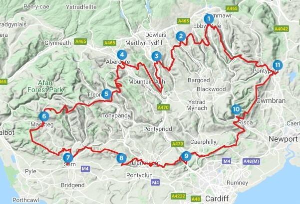
Naturally, the circuit can be done in either direction, starting with any stage (you don’t even have to do it in order!). Some of the easier stages could also be combined to make one longer walk. For me though, the route starts and finishes in Ebbw Vale, and goes in an anti-clockwise direction. This is because the nucleus of the circut were the five walks from Ebbw Vale to Maesteg which were included in the book Walking in the South Wales Valleys. The other six stages that close the circle were developed later and published on this site.
As such, there are no detailed descriptions of those first five stages here, although I hope to add them at some point in future. However, the maps included below for those stages should enable a competent map reader to find their way. Click on the OutdoorActive or OS links to get a map that can be downloaded as a GPX file. Full descriptions for the other six walks – the second half of the circle, from Maesteg back to Ebbw Vale – are available on this site, with links to the relevant pages below. Like most pages on this blog, the descriptions have been written in Welsh, with a link provided at the top of each page to an English version generated by GoogleTranslate.
Here then is a brief outline of the 11 stages of Caradog’s Campaign – click on the links and maps below for more details of each stage.
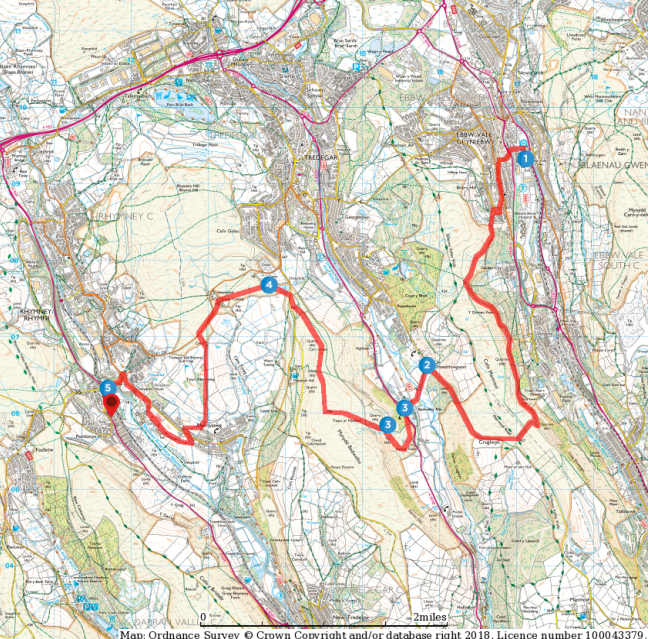
1. Ebbw Vale to Pontlottyn: 8.5 miles, Easy / Moderate. A journey across three valleys – Ebbw, Sirhowy and Rhymney, and two ridges – Cefn Manmoel and Bedwellty Mountain. Includes the remote hilltop cholera cemetery at Cefn Goleu, Tredegar.
OutdoorActive. Ordnance Survey
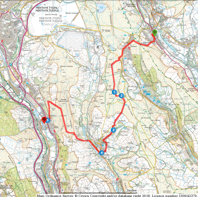
2. Pontlottyn to Troedyrhiw: 8 miles, Easy / Moderate. From the Rhymney valley to the Taff through Taf Bargoed. A variety of landscapes, including Carn y Bugail with its stone age and Roman remains, the pleasant village of Bedlinog, and Mynydd Cilfach-yr-Encil looking down on Merthyr Tydfil.
OutdoorActive. Ordnance Survey
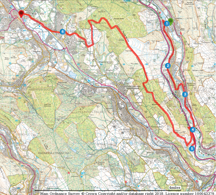
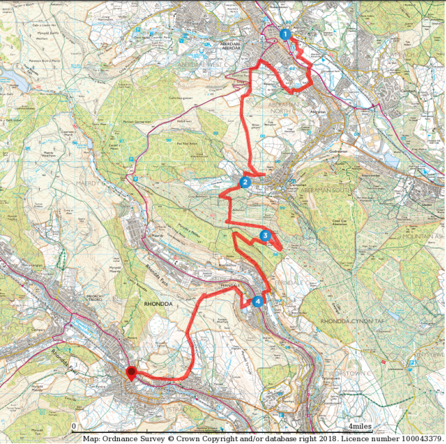
3. Troedyrhiw to Aberdare: 11 miles, Moderate. The Taff and the Cynon Valleys. The first section is flat as it follows the Taff along old tramways and towpaths, including through Aberfan. The second section follows the ridge along Twyn Brynbychan and Mynydd Merthyr before descending to Aberdare. OutdoorActive. Ordnance Survey
4. Aberdare to Ton Pentre: 11 miles, Moderate / Difficult. From the Cynon to the Rhondda Fawr through the Amman and Rhondda Fach valleys. Includes a Roman camp at Twyn y Briddallt and the town of Ferndale. The slopes become steeper and more spectacular as we head west.
OutdoorActive. Ordnance Survey
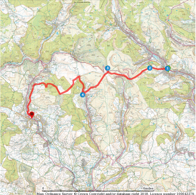
5. Ton Pentre to Maesteg: 13 miles, Difficult. From the Rhondda Fawr to the Llynfi, past the Ogmore and Garw. The most mountainous views of all the walks, including glacial cwms and steep escarpments, with some strenuous climbs. Includes prehistoric sites at Maendy Camp and Crug yr Afan. OutdoorActive. Ordnance Survey
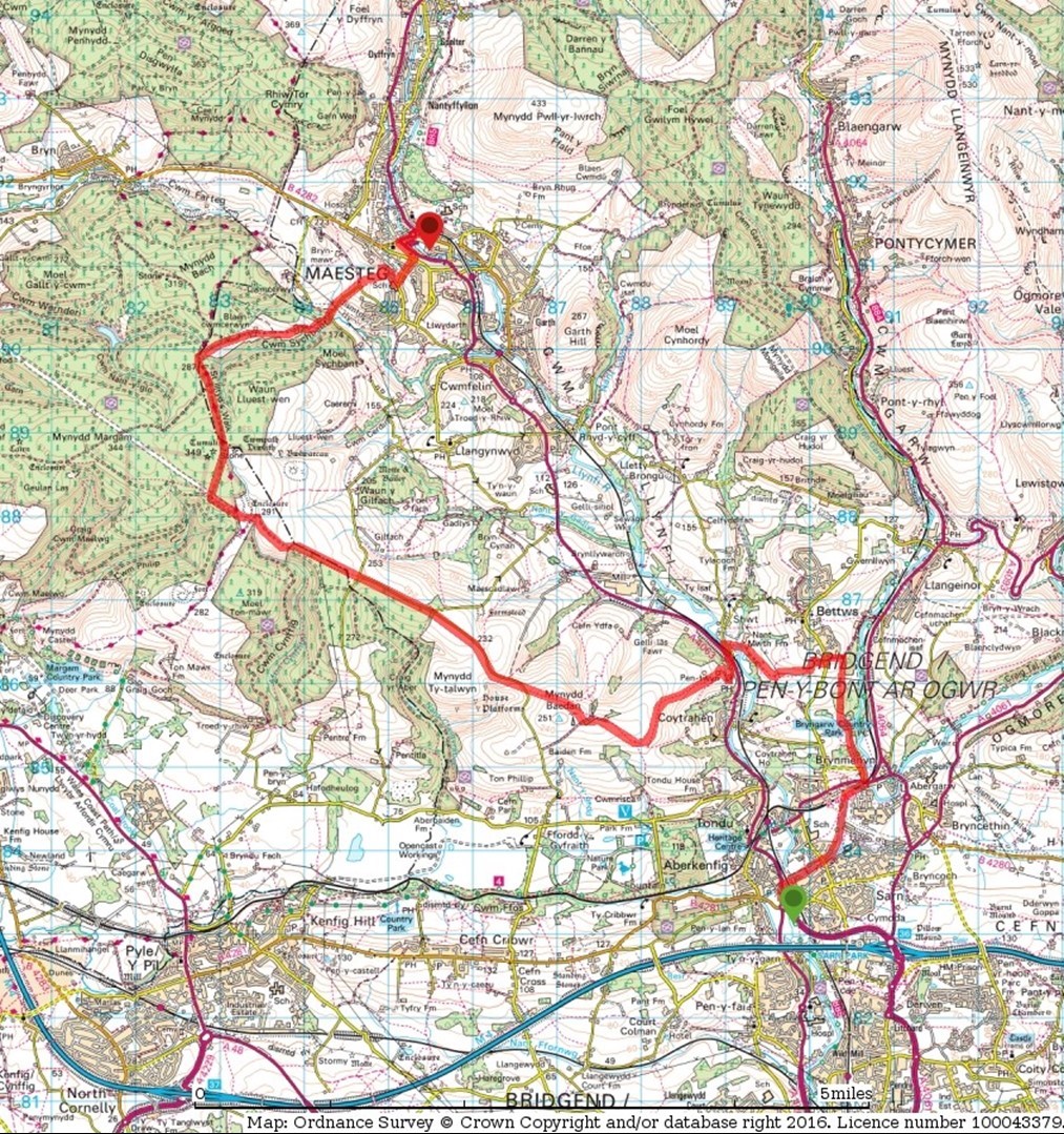
6. Maesteg to Sarn: 12 miles, Moderate. From Maesteg to Sarn near Bridgend, following the old Ffordd y Gyfraith along Mynydd Margam and Mynydd Baedan. Includes Bronze Age cairns, Iron Age forts and post-Roman inscribed stones. Description.
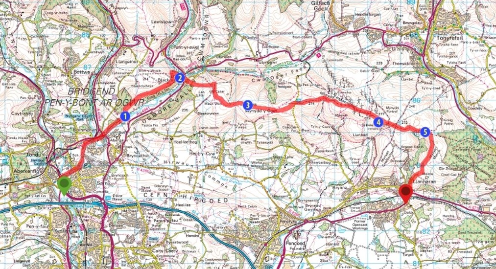
7. Sarn to Llanharan: 10.5 miles, Moderate. Up the Ogmore valley to the historic village of Blackmill – an important crossroads for centuries. From there over Mynydd y Gaer – the possible location of one of Caradog’s battles – and past the ruins of Llanbedr-ar-Fynydd, before finishing at Llanharan. Description.
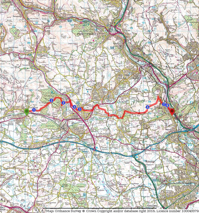
8. Llanharan to Taff’s Well: 11 miles, Moderate. An interesting walk along the ridgeway, including the impressive Llanharan House, the old Ynysmaerdy colliery, the historic town of Llantrisant, Rhiwsaeson, the Garth, and the pleasant villages of Gwaelod y Garth and Taff’s Well. Description.
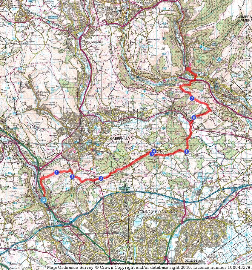
9. Taff’s Well to Crosskeys: 14 miles, Moderate / Difficult. Another interesting and enjoyable walk involving two Marilyns – Craig yr Allt and Mynydd Machen; two castles – Ruperra and Meredydd; woodlands, and plenty of opportunities for quenching your thirst. Description.
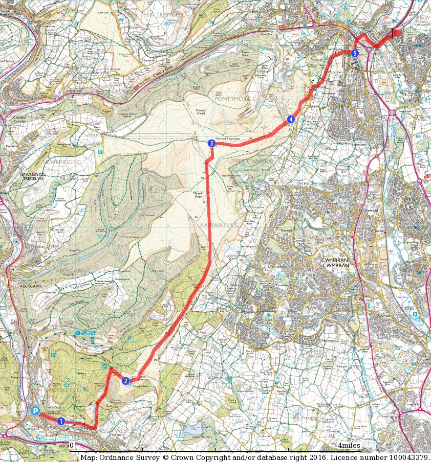
10. Crosskeys to Pontypool: 9 miles, Easy / Moderate. The easiest of the walks, starting and finishing on canal banks with the long ridge of Mynydd Henllys and Mynydd Twyn Glas in between leading us to the heart of old Monmouthshire. Along the way is the Twmbarlwm hillfort, and a site of old iron ore ‘scouring’ works. Description.
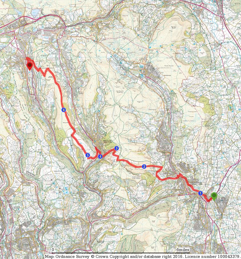
11. Pontypool to Ebbw Vale: 16 miles, Difficult. A long stage to end, connecting two towns that were at the heart of the south Wales iron industry. Much of the walk is along open hillsides, giving broad views and with some little surprises along the way. Description.
Caradog’s Campaign is one of two long distance journeys that can be made by combining the individual walks on this site. The other – Olwen’s Odyssey – is a 98 mile linear route from Abergavenny to Ammanford.
