
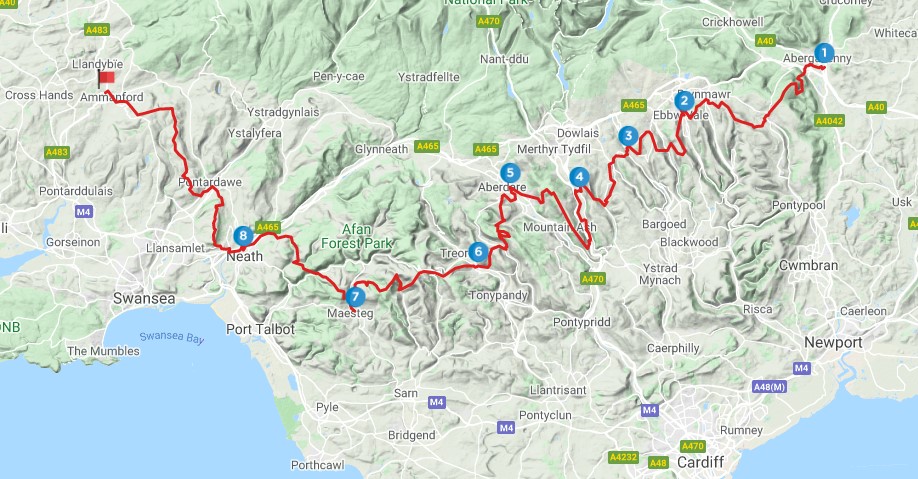
Olwen’s Odyssey is a linear 98 mile walking route the valleys of south Wales, from Abergavenny in the east to Ammanford in the west. It is divided into 8 sections, each starting and ending at a train station.
In the legend of Culhwch ac Olwen, Ysbaddaden Bengawr sets forty tasks for Culhwch to accomplish before he can marry his daughter Olwen. The Twrch Trwyth hunt is particularly associated with the Aman valley area, where this series of walks ends. By coincidence, there are a total of forty obstacles – in the form of hills and rivers – to be crossed along the way: see the bottom of the page for a full list.
Naturally, the traverse can be done in either direction, and some of the easier sections could also be combined to make one longer walk. But it is from east to west that the walks are described here, with the exception (for reasons I can’t remember) of the first leg which has been described the ‘wrong’ way, heading eastwards from Ebbw Vale to Abergavenny. As with Caradog’s Campaign, the nucleus of the idea was the five walks from Ebbw Vale to Maesteg included in the volume Walking in the South Wales Valleys. The other three legs were devised later, and published on this website.
As such, there are currently no detailed descriptions of these five ‘original’ sections on this site – the plan is to add them in the future. However, the maps included below for those legs should be more than enough to enable a competent walker/map-reader to find their way. Click on the OutdoorActive or OS links to get a map that can be downloaded as a GPX file. Full descriptions for the other three section are available here on this site, with links to the relevant pages below.
Below is a brief outline of the 8 legs of Olwen’s Odyssey – click on the links and maps below for more details on each section.
1. Abergavenny to Ebbw Vale: 16 miles, Difficult. From Abergavenny over the Blorenge to Blaenavon, before continuing over Mynydd Coity to Nantyglo and Ebbw Vale. A varied walk – much of it over high moorland. Description.

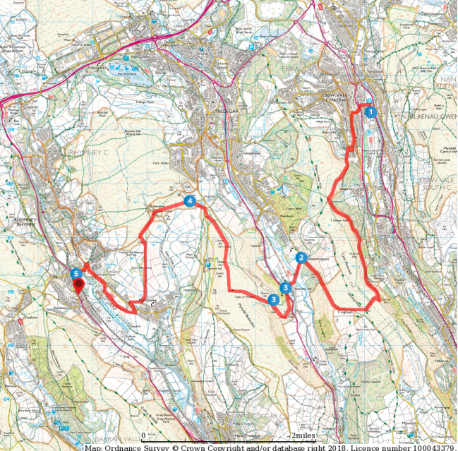
2. Ebbw Vale to Pontlottyn: 8.5 miles, Easy / Moderate. A journey across three valleys – Ebbw, Sirhowy and Rhymney, and two ridges – Cefn Manmoel and Bedwellty Mountain. Includes the remote hilltop cholera cemetery at Cefn Goleu, Tredegar. OutdoorActive. Ordnance Survey
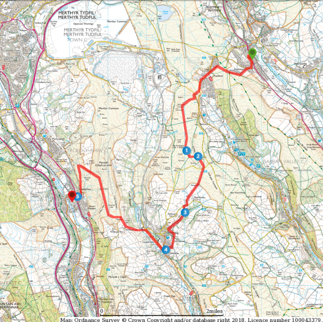
3. Pontlottyn to Troedyrhiw: 8 miles, Easy / Moderate. From the Rhymney valley to the Taff through Taf Bargoed. A variety of landscapes, including Carn y Bugail with its stone age and Roman remains, the pleasant village of Bedlinog, and Mynydd Cilfach-yr-Encil looking down on Merthyr Tydfil.
OutdoorActive. Ordnance Survey
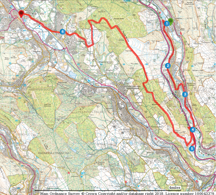
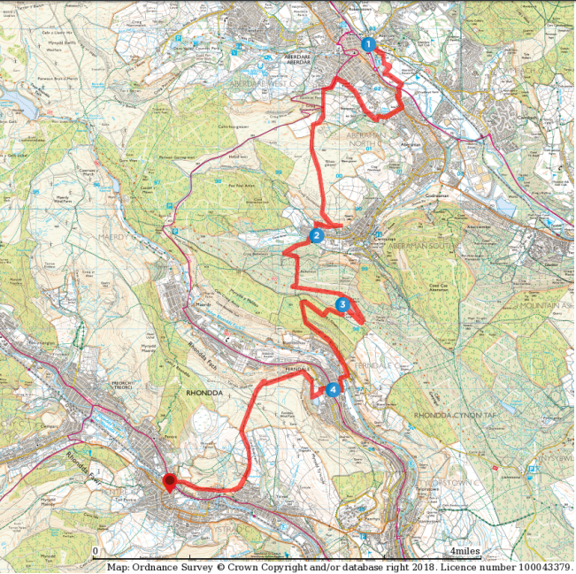
4. Troedyrhiw to Aberdare: 11 miles, Moderate. The Taff and the Cynon Valleys. The first section is flat as it follows the Taff along old tramways and towpaths, including through Aberfan. The second section follows the ridge along Twyn Brynbychan and Mynydd Merthyr before descending to Aberdare. OutdoorActive. Ordnance Survey
5. Aberdare to Ton Pentre: 11 miles, Moderate / Difficult. From the Cynon to the Rhondda Fawr through the Amman and Rhondda Fach valleys. Includes a Roman camp at Twyn y Briddallt and the town of Ferndale. The slopes become steeper and more spectacular as we head west. OutdoorActive. Ordnance Survey
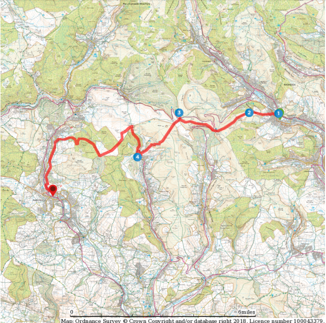
6. Ton Pentre to Maesteg: 13 miles, Difficult. From the Rhondda Fawr to the Llynfi, past the Ogmore and Garw. The most mountainous views of all the walks, including glacial cwms and steep escarpments, with some strenuous climbs. Includes prehistoric sites at Maendy Camp and Crug yr Afan. OutdoorActive. Ordnance Survey
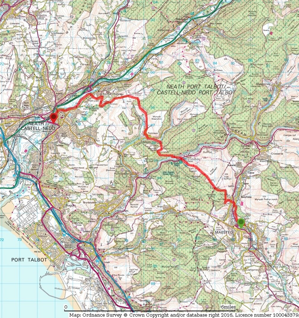
7. Maesteg to Neath: 13 miles, Moderate. From the Llynfi to the Neath valley over the hills of western Glamorgan, crossing the Afan valley on the way. A chance to visit the South Wales Miners Museum in Afan Forest Park. Description.
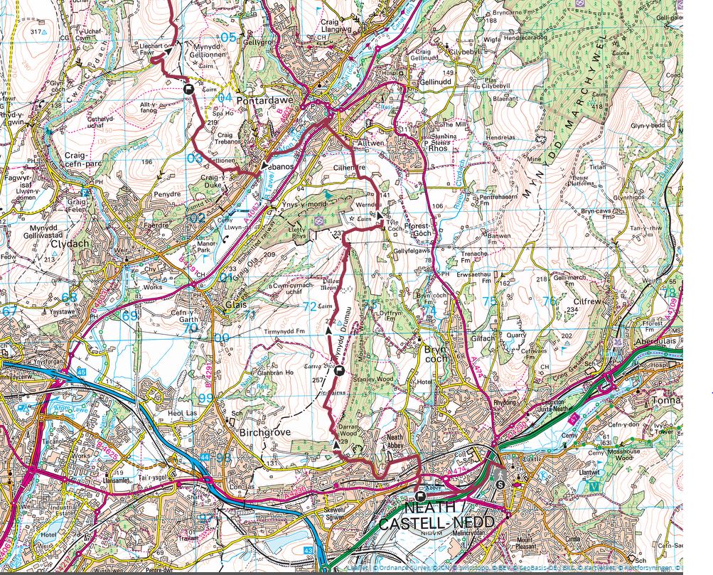
8. Neath to Ammanford: 20 miles, Difficult. The longest of all the walks to finish the series, but one that’s worth every step. Neath Abbey, the Carreg Bica on Mynydd Drumau, Gellionnen and Baran chapels, Carnllechart burial chamber. Views in all directions, and of course – the satisfaction of completing the route! Description.
Olwen’s Odyssey is one of two long-distance routes that can be created by combining the individual walks on this website. The other is Caradog’s Campaign, and an introduction to that route – a 124-mile circular – can be found here.
* The 40 tasks or obstacles on this route are: 1. River Usk; 2. The Blorenge; 3. Afon Llwyd; 4. Mynydd Coity; 5. Ebbw Fach river; 6. Bwlch y Garn; 7. Ebbw Fawr river; 8. Cefn Manmoel; 9. Sirhywi river; 10. Mynydd Bedwellty; 11. Rhymni river; 12. Cefn y Brithdir; 13. Rhymni Bargoed river; 14. Mynydd Fochriw/Carn y Bugail; 15. Taf Bargoed river; 16. Mynydd Cilfach yr Encil; 17. Taff river; 18. Mynydd Merthyr; 19. Cynon river; 20. Rhos Gwawr; 21. Amman river; 22. Twyn y Briddallt; 23. Rhondda Fach river; 24. Cefn y Rhondda; 25. Rhondda Fawr river; 26. Mynydd Maendy; 27. Werfa; 28. Garw river; 29. Llyndwr Fawr; 30. Llynfi river; 31. Foel Trawsant/Cefn yr Argoed; 32. Afan river; 33. Craig y Gyfylchi; 34. Pelenna river; 35. Blaen-cwmbach; 36. Neath river; 37. Mynydd Drumau; 38. Tawe river; 39. Mynydd Carnllechart/Mynydd y Betws; 40. Aman river
